Types of Survey
In this article, I discussed nine different types of surveys, providing a comprehensive understanding of their applications and methodologies.
Surveys play a vital role in collecting data and information about specific areas, projects, or phenomena.
They are widely used in various fields such as engineering, construction, environmental studies, transportation, and urban planning.
Each survey type serves a specific purpose and utilizes different tools and techniques.
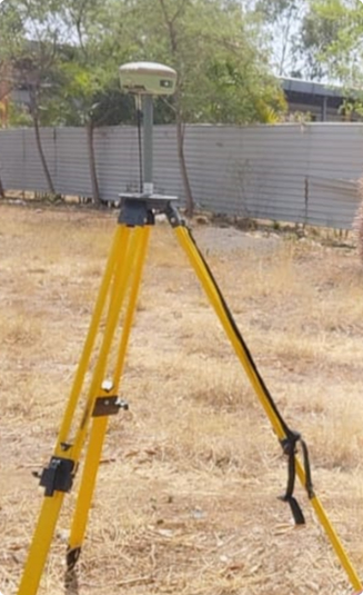
1. Topographical Survey
A topographical survey is conducted to map the natural and man-made features of a particular area.
It focuses on capturing accurate measurements of the terrain, including elevation, slopes, contours, vegetation, water bodies, and structures.
The surveyors employ advanced instruments like GPS (Global Positioning System), total stations, and laser scanners to create detailed topographic maps.
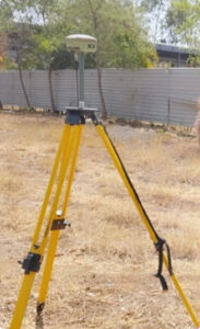
These maps are essential for various purposes, such as land development, infrastructure planning, and architectural design.
2. Hydrology Survey
A hydrology survey involves the assessment of water resources, including rivers, streams, lakes, and groundwater. Its primary objective is to understand the quantity, quality, and behaviour of water in a specific area. By collecting data on water flow rates, water levels, and water quality parameters, hydrologists can analyse water availability, predict flooding patterns, and develop strategies for water resource management.
Hydrology surveys employ techniques such as stream gauging, water sampling, and the use of specialized equipment like current metres and water level recorders.
3. Contour Survey
A contour survey focuses on determining the shape and elevation of the land by measuring contour lines.
Contour lines connect points of equal elevation, providing a detailed representation of the land’s topography.
This type of survey is crucial for understanding slopes, identifying drainage patterns, and assessing the suitability of land for construction or agricultural purposes.
The surveyors use instruments like total stations and GPS receivers to establish accurate contour lines, which are depicted on contour maps.
4. Hydrogeology Survey
A hydrogeology survey aims to investigate the properties and behaviour of groundwater systems.
It involves assessing the geology, porosity, permeability, and water table levels in a specific area.
Hydrogeologists conduct pumping tests, install monitoring wells, and analyze water samples to determine the quantity and quality of groundwater resources. This information is vital for sustainable groundwater management, well siting, and the protection of water supplies.
5. Drone Survey
Drone surveys, also known as aerial surveys, utilize unmanned aerial vehicles (UAVs) equipped with cameras or LiDAR (Light Detection and Ranging) sensors to capture high-resolution imagery and terrain data.
These surveys offer a cost-effective and efficient method for collecting data over large areas.
Drones can be used for various applications, such as mapping, monitoring construction sites, conducting environmental assessments, and creating 3D models.
The collected data can be processed to generate accurate orthophotos, digital elevation models (DEMs), and point clouds.
6. Theodolite Survey
A theodolite survey involves the use of a theodolite, an optical instrument used for measuring angles in both the horizontal and vertical planes.
It is widely used in construction, engineering, and land surveying.
The theodolite allows surveyors to accurately determine horizontal and vertical angles between points, enabling precise measurements for mapping and layout purposes.
The data collected using theodolites is crucial for construction site planning, boundary surveys, and alignment of infrastructure projects.
7. Dumpy Level Survey
A dumpy level survey employs a dumpy level, an optical instrument similar to a theodolite but primarily used for determining height differences or elevations.
It is commonly used in construction projects to establish reference points and set levels.
Surveyors use dumpy levels in conjunction with levelling staffs to measure height variations across a site accurately.
This type of survey is instrumental in creating level platforms, establishing drainage patterns, and ensuring proper foundation levels.
8. Traffic Survey
Traffic surveys are conducted to gather data about vehicle movements, traffic flow patterns, and road usage.
These surveys provide critical information for traffic engineering, urban planning, and transportation infrastructure design.
Techniques used in traffic surveys include manual counts, automated traffic counters, video recordings, and vehicle classification studies.
The data collected helps analyze congestion, identify high-traffic areas, and devise strategies for traffic management and road safety improvements.
9. Total Vehicle Count Survey
A total vehicle count survey aims to determine the overall volume of vehicles passing through a specific location during a given time period.
It provides valuable insights into traffic patterns, peak hours, and road usage. Total vehicle count surveys are often conducted using automated traffic counters or manual observations.
The collected data helps transportation authorities make informed decisions regarding road capacity, traffic signal timing, and infrastructure upgrades.
At Vgeotech Experts, we are proud to offer a comprehensive range of surveys, including those mentioned previously. Our team, led by Chief Dr. Abhinav Mane, has extensive expertise in conducting these surveys with precision and professionalism. We are dedicated to providing accurate and reliable results for each survey type, ensuring that our clients receive the highest level of service. Whether you require environmental surveys, geological surveys, or any other type mentioned, you can trust Vgeotech Experts to deliver exceptional quality and expertise.