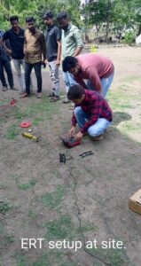
Electrical Resistivity Tomography (ERT)
In this article, I discussed the principle of Electrical Resistivity Tomography (ERT), the Procedure to perform ERT, the Application of ERT and the benefits of ERT in detail.
Electrical Resistivity Tomography (ERT) is a geophysical imaging technique that provides insights into the subsurface by measuring variations in electrical resistivity. By injecting electrical currents into the ground and measuring resulting potentials, ERT enables the calculation of resistance and resistivity values at different depths and locations.
These resistivity variations can then be correlated with changes in lithology, water saturation, fluid conductivity, porosity, and permeability.
Principles of ERT
The underlying principle of ERT is Ohm’s Law, which states that the electrical current passing through a material is inversely proportional to its resistance.
Different materials have distinct resistivity values due to their varying ability to conduct electricity. For example, materials with high resistivity, such as air or sand, have low conductivity, while materials with low resistivity, like clay or water, exhibit high conductivity.
The Procedure for ERT
Equipment Setup:
ERT surveys require the placement of electrodes in the ground.
Current electrodes are responsible for injecting electrical currents, while potential electrodes measure the resulting potentials.
The number and spacing of electrodes depend on the desired resolution and depth of investigation.
Electrodes can be positioned on the ground surface or within boreholes.

Current Injection:
A known electrical current is injected into the ground through the current electrodes.
The current is typically low magnitude to avoid any adverse effects on the subsurface or electrodes.
The injected current travels through the subsurface, encountering materials with varying resistivity.
Potential Measurement:
The resulting electrical potential is measured at the potential electrodes, which are located away from the current electrodes.
The potential measurement is performed using a separate set of electrodes or by switching the electrodes between injection and measurement modes. These potential measurements provide valuable information about the electrical response of the subsurface.
Data Acquisition:
The process of injecting current and measuring potential is repeated for different electrode configurations, forming an array of measurements.
By systematically changing the positions of the electrodes, a complete dataset is acquired, capturing variations in electrical resistivity at different depths and locations.
Data Interpretation:
The acquired data is processed and analyzed to generate a resistivity model of the subsurface.
This involves solving an inverse problem, where the measured resistivity data is used to estimate the resistivity distribution underground.
Inversion algorithms and mathematical techniques are employed to reconstruct the subsurface resistivity distribution.
Result Presentation:
The final output of an ERT survey is typically presented as a resistivity model or resistivity cross-sections.
These visual representations depict the variations in electrical resistivity at different depths and spatial locations.
Geophysicists and geoscientists interpret these images to identify subsurface structures, lithological changes, water tables, fractures, and other geological features of interest.
Applications of ERT are as follows
Geotechnical Engineering:
Assessing soil and rock properties, identifying potential slope stability issues, and characterizing subsurface conditions for foundation design.
Environmental Studies:
Mapping groundwater contamination plumes, detecting leaks from landfills and waste disposal sites, monitoring the migration of contaminants in soil and groundwater.
Hydrogeology:
Delineating aquifers, determining groundwater flow patterns, and studying subsurface water resources.
Archaeology:
Locating buried structures, mapping archaeological features, and identifying ancient settlements or artifacts.
Mineral Exploration:
Identifying mineral deposits and mapping subsurface geology for resource exploration.
Civil Infrastructure:
Assessing the condition of underground utilities, detecting voids or sinkholes that may pose risks to infrastructure.
Benefits of ERT
ERT offers several advantages that make it a valuable geophysical method:
Non-invasive:
ERT is a non-destructive technique that does not require drilling or excavation, minimizing environmental impact.
Versatility:
ERT can be applied in various environments, including land, marine, and freshwater systems, making it suitable for a wide range of applications.
Cost-effective:
Compared to invasive methods like drilling or excavation, ERT is relatively cost-effective while providing valuable subsurface information.
High Resolution:
ERT can provide detailed images of subsurface variations, allowing for precise mapping of geological features and structures.
Long-term Monitoring:
ERT surveys can be repeated over time to monitor changes in the subsurface, making it useful for long-term monitoring projects.
Complementary Technique:
ERT can be used in conjunction with other geophysical methods, such as electromagnetic mapping or ground-penetrating radar (GPR), to enhance subsurface characterization and provide a more comprehensive understanding of the subsurface.
Electrical Resistivity Tomography is a powerful geophysical technique that enables the imaging and mapping of subsurface resistivity variations.
By providing valuable information about lithology, water saturation, fluid conductivity, and more, ERT has widespread applications in engineering, environmental studies, hydrogeology, archaeology, and mineral exploration. With its non-invasive nature, versatility, and cost-effectiveness, ERT continues to contribute to our understanding of the hidden depths beneath the Earth’s surface.
At Vgeotech Experts, our engineers perform this test with accuracy. The equipment we use are calibrated and all our testing services are verified and tested. We follow all Indian standards to perform the test to get accurate required informations.

